
Tag: imaging

Digital imaging tools make maize breeding much more efficient

Mainassara Zaman-Allah conducts a demonstration of the use of unmanned aerial vehicles (UAV) at the Chiredzi research station in Zimbabwe.

To keep up with growing maize demand, breeders aim at optimizing annual yield gain under various stress conditions, like drought or low fertility soils. To that end, they identify the genetic merit of each individual plant, so they can select the best ones for breeding.

To improve that process, researchers at the International Maize and Wheat Improvement Center (CIMMYT) are looking at cost-effective ways to assess a larger number of maize plants and to collect more accurate data related to key plant characteristics. Plant phenotyping looks at the interaction between the genetic make-up of a plant with the environment, which produces certain characteristics or traits. In maize, for example, this may manifest in different leaf angles or ear heights.

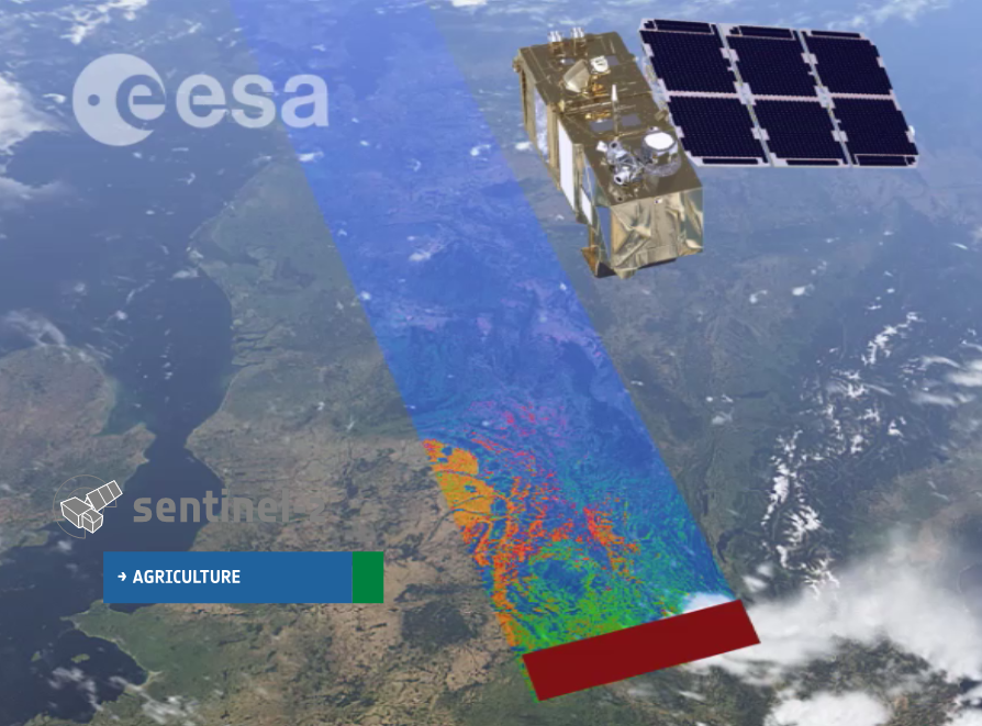
Recent innovations in digital imagery and sensors save money and time in the collection of data related to phenotyping. These technologies, known as high-throughput phenotyping platforms, replace lengthy paper-based visual observations of crop trials.

Authors of a recent review study on high-throughput phenotyping tools observe that obtaining accurate and inexpensive estimates of genetic value of individuals is central to breeding. Mainassara Zaman-Allah, an abiotic stress phenotyping specialist at CIMMYT in Zimbabwe and one of the co-authors, emphasizes the importance of improving existing tools and developing new ones. “Plant breeding is a continuously evolving field where new tools and methods are used to develop new varieties more precisely and rapidly, sometimes at reduced financial resources than before,” he said. “All this happens to improve efficiency in breeding, in order to address the need for faster genetic gain and reduction of the cost of breeding.”

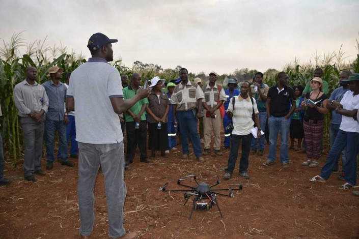
“Under the Stress Tolerant Maize for Africa (STMA) project, we are working on implementing the use of drone-based sensing, among other breeding innovations, to reduce time and cost of phenotyping, so that the development of new varieties costs less,’’ said Zaman-Allah. “The use of drones cuts time and cost of data collection by 25 to 75 percent  compared to conventional methods, because it enables to collect data on several traits simultaneously — for example canopy senescence and plant count,” he explained.

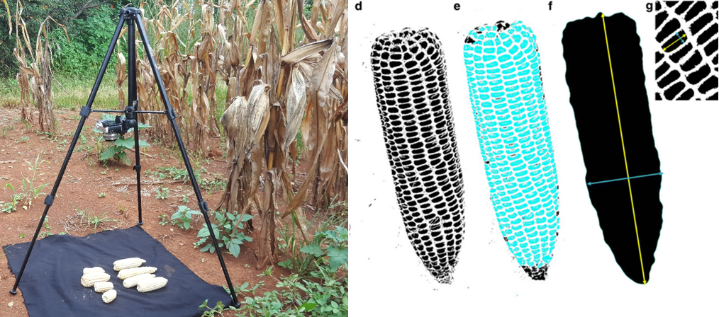
Another great innovation developed under this CIMMYT project is what Zaman-Allah calls the ear analyzer. This low-cost digital imaging app allows to collect maize ear and kernel trait data 90 percent faster. This implies higher productivity and rigor, as more time is dedicated to data analysis rather than time spent on data collection. Using digital image processing, the ear analyzer gives simultaneous data of more than eight traits, including ear size and number, kernel number, size and weight.

Measuring maize attributes such as ear size, kernel number and kernel weight is becoming faster and simpler through digital imaging technologies.

Some national agricultural research systems and NGOs have adopted this digital imagery tool to better assess maize yields in farmers’ fields. For instance, CIMMYT and GOAL have used this tool to assess the extent of fall armyworm impact on maize crops yield in eastern Zimbabwe.

Scientists are exploring the use of different sensors for phenotyping, such as Red, Green and Blue (RGB) digital imaging or Light Detection and Ranging (LIDAR) devices. Infrared thermal and spectral cameras could lead to further progress towards faster maize breeding.

Such sensors can help collect numerous proxy data relating to important plant physiological traits or the plant environment, like plant height and architecture, soil moisture and root characteristics. This data can be used to assess the maize crop yield potential and stress tolerance.

Such breeding innovations are also making maize research more responsive to climate change and emerging pests and diseases.

European Space Agency selects CIMMYT to pilot new remote sensing project

Signing ceremony (L-R) with Pierre Defourny, Urs Schulthess, Kai Sonder, Bruno Gérard and Francelino Rodrigues giving CIMMYT access to the pilot version of the Sen2-Agri processing system and receive training on its use. Photo: Liliana Díaz Ramírez

EL BATAN, Mexico (CIMMYT) – The International Maize and Wheat Improvement Center (CIMMYT) has been selected by the European Space Agency (ESA) to have access to the pilot version of the Sen2-Agri processing system and receive training on its use.

As an ESA “champion user,” CIMMYT will test the ESA prototype system in Bangladesh and Mexico. These two sites cover a wide range of farming systems, from the large wheat fields of the Yaqui Valley to a more diverse system in Bangladesh, where parcel sizes can be as small as 0.05 hectares and farmers grow two to three crops per year on a single field.

“The great unmanned aerial vehicle (UAV) expertise acquired by CIMMYT is very complementary to the full exploitation of the new satellite generation capabilities,” says Pierre Defourny, professor at the Université catholique de Louvain in Belgium who is leading the Sen2-Agri project. “CIMMYT’s two cases will generate products that will support our joint efforts for wheat blast monitoring in Bangladesh and improve data availability for GreenSat in Mexico.”

In the early days of remote sensing, limited availability of data was a major constraint for putting the data to good use. Basic processing of the coarse data was also time consuming and tedious.

Fortunately, this has greatly changed in recent years. Open and free satellite data, such as Landsat 8 and Sentinel 1 & 2, allow for almost weekly coverages at resolutions as fine as 10 meters. Thanks to this new speed and precision, users can now focus on applying the data, deriving information products even for small holder farmers in remote areas.

The Sentinel 2 satellites have a swath width of 290 km. Sentinel-2A is already operational, while Sentinel-2B will be launched in the spring of 2018. Together, they will be able to cover the Earth every 5 days.

For example, the CIMMYT-led STARS project in Bangladesh developed an irrigation scheduling app called PANI, which uses remotely sensed data to estimate crop water use. From this data the farmer receives a simple text message on their cell phone that gives recommendations as to whether a particular field needs to be irrigated or not.

Sen2-Agri is unique compared to other systems in that it simplifies and automates satellite data processing. The system allows for semi-automated generation of products, such as cropland detection, crop classification, normalized difference vegetation index (NDVI) and leaf area index (LAI) based on images taken periodically by satellites Sentinel-2 and Landsat 8.

A signing ceremony was held on 15 August, 2016 to seal the cooperation between ESA and CIMMYT. Bruno Gérard, Director of CIMMYT’s Sustainable Intensification Program, sees this agreement as a fundamental game changer for CIMMYT’s geo-spatial work.

“Sen2-Agri will give CIMMYT access to high spatial and temporal resolution quality imagery and related ‘know-how,’ which in turn will enable us to further develop partnership with top-notch institutions in the earth observation field,” says Gérard.

Interface of the Sen2-Agri system, which allows for a semi-automated generation of cropland, crop type, LAI and NDVI maps.

The benefits of the Sen2-Agri are likely to far extend beyond the Yaqui Valley and Bangladesh. After the pilot phase of this project, the high-resolution imagery gathered could be applied to other areas CIMMYT projects are implemented.

In combination with bio-physical and socio-economic data, this will allow CIMMYT and other organizations to improve monitoring and evaluation, better assess and understand changes and shocks in crop-based farming systems and improve technology targeting across farmer communities.

The Sen2-Agri test program is being coordinated by Urs Schulthess. Please feel free to contact him at u.schulthess@cgiar.org if you have questions about or suggestions for future applications of the system.