
Tag: big data

Launching the AgriFoodTrust platform

A new testing and learning platform for digital trust and transparency technologies — such as blockchain — in agri-food systems was launched at the Strike Two Summit in late February. 

AgriFoodTrust debuted at the summit which brought together key agri-food system players to discuss how blockchain and related technologies can contribute to food safety, quality and sustainability, said Gideon Kruseman, an economist with the International Maize and Wheat Improvement Center (CIMMYT), who co-founded the platform. 

“Blockchain is often associated with the digital security that led to cryptocurrencies. However, growing research is providing evidence on its unique potential to bring greater efficiency, transparency and traceability to the exchange of value and information in the agriculture sector,” said Kruseman. 

“Many of the wicked problems and seemingly insuperable challenges facing dynamic, complex agri-food system value chains, especially in low and middle-income countries, boil down to a lack of trust, transparency and reliable governance structures,” said the researcher who also leads the Socio-Economic Data Community of Practice of the CGIAR Platform for Big Data in Agriculture 

Future Food panelist speak at the Strike Two Summit in Amsterdam, the Netherlands. (Photo: The New Fork)

A blockchain is a ledger that is almost impossible to forge. It can be described as a data structure that holds transactional records and ensures security, transparency and decentralization. Technology may be at the foundation of the solutions, but technology is the easy part; solving the softer side has proven to be a seemingly insuperable challenge over the past decades, Kruseman explained. 

Digital trust and transparency technologies can be used to improve governance structures and limit corruption in agri-food systems in low and middle income countries, said Marieke de Ruyter de Wildt, co-founder of AgriFoodTrust. 

“This new generation of decentralized technologies is, in essence, improving governance structures. People often think it is about technology, but it’s not. It is about people and how we organize things.”  

“These technologies are neutral, immutable and censorship resistant. You can mimic this if you think about rules without a ruler. Just imagine what opportunities arise when a system is incorruptible,” said de Ruyter de Wildt.  

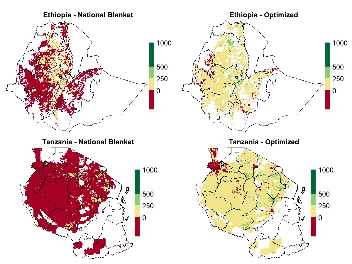
It is hoped, accessible via QR codes, for example, that the technology can be used to tackle challenges, such as preventing the sale of counterfeit seeds to smallholder farmers, ensuring the nutritional value of biofortified crop varieties and promoting the uptake of sustainable agricultural principles whilst improving the implementation and monitoring of international agreements related to agriculture. 

“This is where the platform comes in as a knowledge base. The AgriFoodTrust platform sees researchers from CGIAR Centers and academia, such as Wageningen University, experiment with these technologies on top of other solutions, business models and partnerships to determine what works, how, when and for whom, in order to share that information,” Kruseman added. 

Findings on the new platform will be used to build capacity on all aspects of the technologies and their application to ensure this technology is inclusive and usable. 

Along with KrusemanAgriFoodTrust co-founders include digital agriculture experts de Ruyter de Wildt, the Founder and CEO of The New Fork, and Chris Addison, Senior Coordinator of Data for Agriculture at CTA. Seed funding for the platform has been raised through CTA, the CGIAR Platform for Big Data in Agriculture and the CGIAR Programs on MAIZE and WHEAT. 

“AgriFoodTrust sets out to accelerate understanding about these technologies and fundamentally make food systems more integer and resilient,” explained de Ruyter de Wildt. 

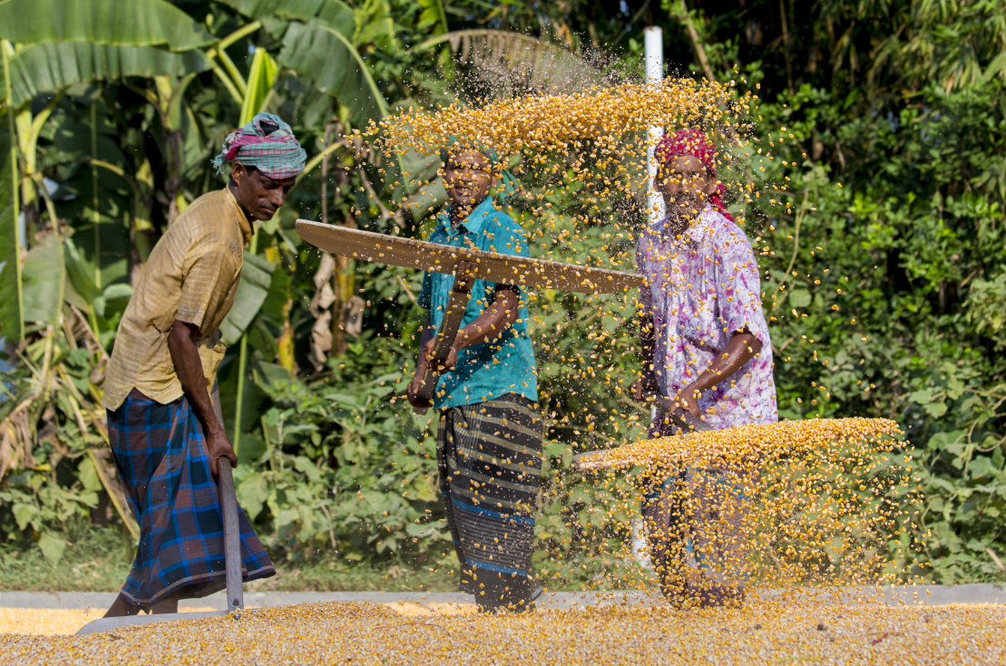
By 2050, farmers will need to grow enough diverse and nutritious food to feed 10 billion people on less land using less resources while faced with the challenges of a changing climate. This has led researchers to push for agricultural technologies that engender more inclusive, sustainable food systems. It is hoped that increased trust and transparency technologies can help overcome counterproductive incentives, poor governance structures, prevailing institutional arrangements and market failures. 

For more information, subscribe to the Socio-Economic Data Community of Practice newsletter.

Gerald Blasch

Gerald Blasch is a Crop Disease Geo-Spatial Data Scientist whose work focuses on research for development (R4D) of remote sensing and geospatial solutions for crop disease early warning systems. He holds a PhD in Agricultural Remote Sensing from Technical University Berlin, Germany, and an MSc in Physical Geography from University Regensburg, Germany.

Blasch has 13 years of research and consultancy experience on both international and national projects in the agriculture and development sectors of several countries (e.g. Australia, China, Germany, Mexico, and the UK). As researcher, he developed remote sensing and GIS tools for precision and conservation agriculture, digital soil mapping, and environmental monitoring during his Post-Doc (Newcastle University, UK) and PhD studies (GFZ Potsdam, Germany), and consultancy activities (CIMMYT, Mexico). As a GIS expert (GIZ, Germany; SEMARNAT, Mexico) he built and managed a GIS for waste management, including capacity building and knowledge transfer.

Big data analytics for climate-smart agricultural practices in South Asia (Big Data2 CSA)

Heterogeneity in soils, hydrology, climate, and rapid changes in rural economies including fluctuating prices, aging and declining labor forces, agricultural feminization, and uneven market access are among the many factors that constrain climate-smart agriculture (CSA) in South Asia’s cereal-based farming systems.

Most previous research on CSA has employed manipulative experiments analyzing agronomic variables, or survey data from project-driven initiatives. However, this can obscure the identification of relevant factors limiting CSA, leading to inappropriate extension, policy, and inadequate institutional alignments to address and overcome limitations. Alternative big data approaches utilizing heterogeneous datasets remain insufficiently explored, though they can represent a powerful alternative source of technology and management practice performance information.

In partnership with national research systems and the private sector in Bangladesh, India and Nepal, Big data analytics for climate-smart agricultural practices in South Asia (Big Data2 CSA) is developing digital data collection systems to crowdsource, data-mine and interpret a wide variety of primary agronomic management and socioeconomic data from tens of thousands of smallholder rice and wheat farmers.

The project team analyzes these data by stacking them with spatially-explicit secondary environmental, climatic and remotely sensed data products, after which data mining and machine learning techniques are used to identify key factors contributing to patterns in yield, profitability, greenhouse gas emissions intensity and resilience.

These approaches however must be practical in order for them to be useful in agricultural development and policy. As such, the project’s analytical results will be represented through interactive web-based dashboards, with gender-appropriate crop management advisories deployed through interactive voice recognition technologies to farmers in Bangladesh, India and Nepal at a large-scale. Big Data2 CSA is supported by the CGIAR Research Program on Climate Change, Agriculture and Food Security (CCAFS) Flagship 2 on Climate-Smart Technologies and Practices.

Objectives

  • Develop ICT tools enabling digital collection of crop management data and a cloud-based database that can be managed by next-users
  • Support advanced degree-level students to engage in field and data science research
  • Create a digital data collection platform enabling crowd sourcing of crop management information to evaluate contributions to CSA
  • Create interactive and customizable web-based dashboards presenting post-season research results and providing CSA management recommendations
  • Organize CSA and big data policy briefings on mainstreaming processes and policy workshops

Smartphones drive data collection revolution, boost climate-smart agriculture in Bangladesh

Farmer receiving information from a phone-based service. (Photo: Michelle DeFreese/CIMMYT)

Agricultural research is entering a new age in Bangladesh. The days, months and years it takes to collect farm data with a clipboard, paper and pen are nearing their end.

Electronic smartphones and tablets are gaining ground, used by researchers, extension workers and farmers to revolutionize the efficiency of data collection and provide advice on best-bet practices to build resilient farming systems that stand up to climate change.

Digital data collection tools are crucial in today’s ‘big data’ driven agricultural research world and are fundamentally shifting the speed and accuracy of agricultural research, said Timothy Krupnik, Senior Scientist and Systems Agronomist at the International Maize and Wheat Improvement Center (CIMMYT).

“Easy-to-use data collection tools can be made available on electronic tablets for surveys. These allow extension workers to collect data from the farm and share it instantaneously with researchers,” he said.

“These tools allow the regular and rapid collection of data from farmers, meaning that researchers and extension workers can get more information than they would alone in a much quicker time frame.”

“This provides a better picture of the challenges farmers have, and once data are analyzed, we can more easily develop tailored solutions to farmers’ problems,” Krupnik explained.

Through the USAID and Bill and Melinda Gates supported Cereal Systems Initiative for South Asia (CSISA), and the CGIAR Research Program on Climate Change, Agriculture and Food Security (CCAFS) supported Big Data Analytics for Climate-Smart Agriculture in South Asia projects, 125 Department of Agricultural Extension (DAE) agents were trained throughout Bangladesh to use tablets to gather agronomic information from rice and wheat farmers.

It is the first time extension workers have been involved in data collection in the country. Since the pilot began in late 2019, extension workers have collected data from over 5,000 farmers, with detailed information on climate responses, including the management of soil, water and variety use to understand what drives productivity. The DAE is enthused about learning from the data, and plans to collect information from 7,000 more farmers in 2020.

Bangladesh’s DAE is directly benefiting through partnerships with expert national and international researchers developing systems to efficiently collect and analyze massive amounts of data to generate relevant climate-smart recommendations for farmers, said the department Director General Dr. M. Abdul Muyeed.

Workers spread maize crop for drying at a wholesale grain market. (Photo: Dreamstime.com)

For the first time widespread monitoring examines how farmers are coping with climate stresses, and agronomic data are being used to estimate greenhouse gas emissions from thousands of individual farmers. This research and extension partnership aims at identifying ways to mitigate and adapt to climate change, he explained.

“This work will strengthen our ability to generate agriculturally relevant information and increase the climate resilience of smallholder farmers in Bangladesh,” Dr. Muyeed said.

Next-gen big data analysis produces best-bet agricultural practices

“By obtaining big datasets such as these, we are now using innovative research methods and artificial intelligence (AI) to examine patterns in productivity, the climate resilience of cropping practices, and greenhouse gas emissions. Our aim is to develop and recommend improved agricultural practices that are proven to increase yields and profitability,” said Krupknik.

The surveys can also be used to evaluate on-farm tests of agricultural technologies, inform need-based training programs, serve local knowledge centers and support the marketing of locally relevant agricultural technologies, he explained.

“Collecting farm-specific data on greenhouse gas emissions caused by agriculture and recording its causes is a great step to develop strategies to reduce agriculture’s contribution to climate change,” added Krupnik.

Kindie Tesfaye Fantaye

Kindie Tesfaye is a Senior Scientist based in Ethiopia. He has more than 15 years of experience in executing and managing climate, crop modeling and GIS related projects for agricultural research and development in developing countries.

During his time at CIMMYT, he has developed a system of data acquisition and quality control for climate, crop modeling and geospatial analysis. He has applied systems analysis, cropping systems modeling and geospatial analysis tools for yield gap analysis, targeting of climate smart technologies and climate change studies across different scales. In collaboration with partners, he has also developed a digital agro-climate advisory system that provides decision support to smallholder farmers.

MARPLE team recognized for international impact

MARPLE team members Dave Hodson and Diane Saunders (second and third from left) stand for a photograph after receiving the International Impact award. With them is Malcolm Skingle, director of Academic Liaison at GlaxoSmithKline (first from left) and Melanie Welham, executive chair of BBSRC. (Photo: BBSRC)

The research team behind the MARPLE (Mobile And Real-time PLant disEase) diagnostic kit won the International Impact category of the Innovator of the Year 2019 Awards, sponsored by the United Kingdom’s Biotechnology and Biological Sciences Research Council (BBSRC).

The team — Diane Saunders of the John Innes Centre (JIC), Dave Hodson of the International Maize and Wheat Improvement Center (CIMMYT) and Tadessa Daba of the Ethiopian Institute for Agricultural Research (EIAR) — was presented with the award at an event at the London Science Museum on May 15, 2019. In the audience were leading figures from the worlds of investment, industry, government, charity and academia, including the U.K.’s Minister of State for Universities, Science, Research and Innovation, Chris Skidmore.

The BBSRC Innovator of the Year awards, now in their 11th year, recognize and support individuals or teams who have taken discoveries in bioscience and translated them to deliver impact. Reflecting the breadth of research that BBSRC supports, they are awarded in four categories of impact: commercial, societal, international and early career. Daba, Hodson and Saunders were among a select group of 12 finalists competing for the four prestigious awards. In addition to international recognition, they received £10,000 (about $13,000).

“I am delighted that this work has been recognized,” Hodson said. “Wheat rusts are a global threat to agriculture and to the livelihoods of farmers in developing countries such as Ethiopia. MARPLE diagnostics puts state-of-the-art, rapid diagnostic results in the hands of those best placed to respond: researchers on the ground, local government and farmers.”

On-the-ground diagnostics

The MARPLE diagnostic kit is the first operational system in the world using nanopore sequence technology for rapid diagnostics and surveillance of complex fungal pathogens in the field.

In its initial work in Ethiopia, the suitcase-sized field test kit has positioned the country — one of the region’s top wheat producers — as a world leader in pathogen diagnostics and forecasting. Generating results within 48 hours of field sampling, the kit represents a revolution in plant disease diagnostics. Its use will have far-reaching implications for how plant health threats are identified and tracked into the future.

MARPLE is designed to run at a field site without constant electricity and with the varying temperatures of the field.

“This means we can truly take the lab to the field,” explained Saunders. “Perhaps more importantly though, it means that smaller, less-resourced labs can drive their own research without having to rely on a handful of large, well-resourced labs and sophisticated expertise in different countries.”

In a recent interview with JIC, EIAR Director Tadessa Daba said, “we want to see this project being used on the ground, to show farmers and the nation this technology works.”

The MARPLE team uses the diagnostic kit in Ethiopia. (Photo: JIC)

Development of the MARPLE diagnostic kit was funded by the Biotechnology and Biological Sciences Research Council (BBSRC) and the CGIAR Platform for Big Data in Agriculture’s Inspire Challenge. Continued support is also provided by the BBSRC’s Excellence with Impact Award to the John Innes Centre and the Delivering Genetic Gain in Wheat project, led by Cornell University and funded by the UK’s Department for International Development (DFID) and the Bill & Melinda Gates Foundation.

More information on the award can be found on the JIC website, the BBSRC website and the website of the CGIAR Research Program on Wheat.

Wei Xiong

Wei Xiong is an interdisciplinary researcher focusing on the interactions between agricultural production and environment, with specific experiences in climate change and agriculture, development of agricultural system modeling tools, evaluation of climate-smart agriculture, and Genotype by Environment Interaction analysis.

Xiong is good at using cutting-edge technologies (such as cloud computing, machine learning, big data, HPC, and bioinformatics) in G×E×M interaction analysis, with a track record of improving short- and long-term agricultural forecast models at the local, national, and global scales. He is also interested in smart agriculture, agricultural AI, and innovative predictive approaches from genomics to phenomics.

Tek Sapkota

Tek Sapkota currently leads the Climate Change Science Group within CIMMYT’s Sustainable Agrifood Systems (SAS) program and is based in CIMMYT headquarters in Mexico. He carries out research in the area of agricultural systems, soil science and environmental sciences. He is particularly involved in studying agro-ecosystems management consequences on nutrient dynamics and their effect on food security, climate change adaptation and mitigation. He is a member of the Climate Investment Committee in OneCGIAR.

Sapkota has served in IPCC as Lead author as well as Review editor. He is an associate Editor of Nature Scientific Report and Frontiers in Sustainable Food Systems journals. He is an agricultural expert in the India GHG platform.

How the data revolution could help design better agronomic investments

Profitability under different fertilization recommendation scenarios in Ethiopia and Tanzania, measured in U.S. dollars per hectare.

What fertilizer application will give me the best returns? What maize crop variety should I use?

Each farmer faces constraints related to weather uncertainty, soil fertility management challenges, or access to finance and markets. To improve their yields and incomes, African smallholder farmers need agronomic advice adapted to their specific circumstances. The challenge is even greater in sub-Saharan Africa, where agricultural production landscapes are highly diverse. Yet traditional agronomic research was not designed to fit with complex agroecological regions and farming systems. Compounding the problem, research organizations often have limited resources to develop the necessary experiments to generate farm- and site-specific agronomic advice at scale.

“Agronomic research is traditionally not equipped to consider spatial or socio-economic diversity among the millions of farmers it targets,” said Sebastian Palmas, data scientist at the International Maize and Wheat Improvement Center (CIMMYT) in Nairobi, Kenya.

Palmas presented some of the learnings of the Taking Maize Agronomy to Scale in Africa (TAMASA) project during a science seminar called “A spatial ex ante framework for guiding agronomic investments in sub-Saharan Africa on March, 4, 2019.

The project, funded by the Bill & Melinda Gates Foundation, has used data to improve the way agronomic research for development is done. Researchers working on the TAMASA project addressed this challenge by using available geospatial information and other big data resources, along with new data science tools such as machine learning and Microsoft’s AI for Earth. They were able to produce and package information that can help farmers, research institutions and governments take better decisions on what agronomic practices and investments will give them the best returns.

By adapting the Quantitative Evaluation of the Fertility of Tropical Soils (QUEFTS) model to the conditions of small farmers in TAMASA target countries (Ethiopia, Nigeria and Tanzania), using different layers of information, CIMMYT and its partners have developed a versatile geospatial tool for evaluating crop yield responses to fertilizer applications in different areas of a given country. Because calculations integrate spatial variation of fertilizer and grain prices, the tool evaluates the profitability — a key factor influencing farmers’ fertilizer usage — for each location. The project team can generate maps that show, for instance, the estimated agronomic and economic returns to different fertilizer application scenarios.

The TAMASA team plans to publish the code and user-friendly interface of this new geospatial assessment tool later this year. (Photo: CIMMYT)

Making profits grow

These tools could potentially help national fertilizer subsidy programs be more targeted and impactful, like the ambitious Ethiopia’s Fertilizer Blending initiative which distributes up to 250,000 tons of fertilizer annually. Initial calculations showed that, by optimizing diammonium phosphate (DAP) and urea application, the profitability per hectare could improve by 14 percent on average, compared to the current fertilizer recommendations.

Such an approach could generate farm-specific advice at scale and boost farmers’ incomes. It could also provide insights on many different issues, like estimating market demand for a new fertilizer blend, or the estimated quantity of additional fertilizer required to bring about a targeted maize yield increase.

Future extensions of the framework may incorporate varietal differences in nutrient management responses, and thus enable seed companies to use the framework to predict where a new maize hybrid would perform best. Similarly, crop breeders could adapt this ex ante assessment tool to weigh the pros and cons of a specific trait and the potential impact for farmers.

The TAMASA team plans to publish the code and user-friendly interface of this new geospatial assessment tool later this year.

New digital maps to support soil fertility management in Nepal

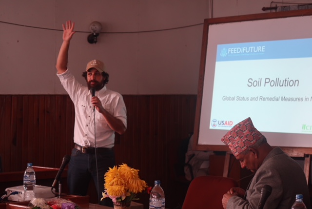
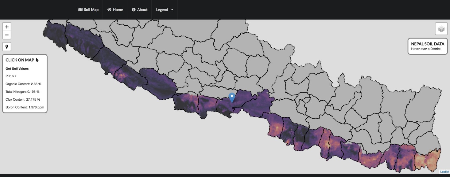
KATHMANDU, Nepal (CIMMYT) — The International Maize and Wheat Improvement Center (CIMMYT) is working with Nepal’s Soil Management Directorate and the Nepal Agricultural Research Council (NARC) to aggregate historic soil data and, for the first time in the country, produce digital soil maps. The maps include information on soil PH, organic matter, total nitrogen, clay content and boron content. Digital soil mapping gives farmers and natural resource managers easy access to location-specific information on soil properties and nutrients, so they can make efficient and localized management decisions.

As part of CIMMYT’s Nepal Seed and Fertilizer (NSAF) project, researchers used new satellite imagery that enabled the resolution of the maps to be increased from 1×1 km to 250×250 m. They have updated the web portal to make it more user friendly and interactive. When loaded onto a smartphone, the map can retrieve the soil properties information from the user’s exact location if the user is within areas with data coverage. The project team is planning to produce maps for the whole country by the end of 2019.

CIMMYT scientist David Guerena talks about the role of the new digital maps to combat soil fertility problems in Nepal.

At a World Soil Day event in Nepal, CIMMYT soil scientist David Guerena presented the new digital soil maps to scientists, academics, policymakers and other attendees. Guerena explained the role this tool can play in combatting soil fertility problems in Nepal.

These interactive digital maps are not simply visualizations. They house the data and analytics which can be used to inform site-specific integrated soil fertility management recommendations.

The first high-resolution digital soil maps for the Terai region have been produced with support from the data assets from the National Land Use Project, developed by Nepal’s Ministry of Agriculture and Livestock Development. These maps will be used to guide field programming of the NSAF project, drive the development of market-led fertilizer products, and inform and update soil management recommendations. The government of Nepal can use the same information to align policy with the needs of farmers and the capacity of local private seed and fertilizer companies.

In 2017, 16 scientists from Nepal’s Soil Management Directorate, NARC and other institutions attended an advanced digital soil mapping workshop where they learned how to use different geostatistical methods for creating soil maps. This year, as part of the NSAF project, four NARC scientists attended a soil spectroscopy training workshop and learned about digitizing soil data management and using advanced spectral methods to convert soil information into fertilizer recommendations.

Soil data matters

Soil properties have a significant influence on crop growth and the yield response to management inputs. For farmers, having access to soil information can make a big difference in the adoption of integrated soil fertility management.

Farmer motivation and decision-making relies heavily on the perceived likeliness of obtaining a profitable return at minimized risk. This largely depends on the yield response to management inputs, such as improved seeds and fertilizers, which depends to a large extent on site-specific soil properties and variation in agro-ecological conditions. Therefore, quantitative estimates of the yield response to inputs at a given location are essential for estimating the risks associated with these investments.

The digital soil maps can be accessed at https://nsafmap.github.io/.

The Nepal Seed and Fertilizer project is funded by the United States Agency for International Development (USAID) and is a flagship project in Nepal. The objective of the NSAF is to build competitive and synergistic seed and fertilizer systems for inclusive and sustainable growth in agricultural productivity, business development and income generation in Nepal.

Are advisory apps a solution for collecting Big Data?

Big Data is transforming the way scientists conduct agricultural research and helping smallholder farmers receive useful information in real time. Experts and partners of the CGIAR Platform for Big Data in Agriculture are meeting on October 3-5, 2018, in Nairobi, Kenya, to share their views on how to harness this data revolution for greater food and nutrition security.

Jordan Chamberlin, Spatial Economist at CIMMYT, will give his insights on best practices on electronic data capture on October 4, 2018.

NAIROBI (Kenya) — Agronomic researchers face several challenges and limitations related to data. To provide accurate predictions and useful advice to smallholder farmers, scientists need to collect many types of on-farm data; for example, field size, area devoted to each crop, inputs used, agronomic practices followed, incidence of pests and diseases, and yield.

These pieces of data are expensive to obtain by traditional survey methods, such as sending out enumerators to ask farmers a long list of questions. Available data is often restricted to a particular geographical area and may not capture key factors of production variability, like local soil characteristics, fertilizer timing or crop rotations.

As a result, such datasets cannot deliver yield predictions at scale, one of the main expectations of Big Data. Digital advisory apps may be part of the solution, as they use crowdsourcing to routinize data collection on key agronomic variables.

The Taking Maize Agronomy to Scale in Africa (TAMASA) project has been researching the use of mobile apps to provide site-specific agronomic advice to farmers through agro-dealers, extension workers and other service providers.

At CIMMYT, one of the research questions we were interested in was “Why are plant population densities in farmers fields usually well below recommended rates?” From surveys and yield estimates based on crop-cut samples at harvest in Ethiopia, Nigeria and Tanzania, we observed that yields were correlated with plant density.

What was making some farmers not use enough seeds for their fields? One possible reason could be that farmers may not know the size of their maize field. In other cases, farmers and agro-dealers may not know how many seeds are in one packet, as companies rarely indicate it and the weight of each seed variety is different. Or perhaps farmers may not know what plant population density is best to use. Seed packets sometimes suggest a sowing rate but this advice is rather generic and assumes that farmers apply recommended fertilizer rates. However, farmers’ field conditions differ, as does their capacity to invest in expensive fertilizers.

To help farmers overcome these challenges, we developed a simple app, Maize-Seed-Area. It enables farmers, agro-dealers and extension workers to measure the size of a maize field and to identify its key characteristics. Then, using that data, the app can generate advice on plant spacing and density, calculate how much seed to buy, and provide information on seed varieties available at markets nearby.

View of the interface of the Maize-Seed-Area app on mobile phones and tablets. (Photo: CIMMYT)

Maize-Seed-Area is developed using the Open Data Kit (ODK) format, which allows to collect data offline and to submit it when internet connection becomes available. In this case, the app is also used to deliver information to the end users.

Advisory apps usually require some input data from farmers, so advice can be tailored to their particular circumstances. For example, they might need to provide data on the slope of their field, previous crops or fertilizer use. Some additional information may be collected through the app, such as previous seed variety use. All this data entered by the user, which should be kept to a minimum, is routinely captured by the app and retrieved later.

Hello, Big Data!

As the app user community grows, datasets on farmer practices and outcomes grow as well. In this case, we can observe trends in real time, for instance on the popularity of different maize varieties.

In a pilot in western Kenya, in collaboration with Precision Agriculture for Development (PAD), some 100 agro-dealers and extension workers used the app to give advice to about 2,900 farmers. Most of the advice was on the amount of seed to buy for a given area and on the characteristics of different varieties.

Data showed that the previous year farmers grew a wide range of varieties, but that three of them were dominant: DK8031, Duma43 and WH505.

Preferred variety of maize for sample farmers in western Kenya (Bungoma, Busia, Kakamega and Siaya counties), February-March 2018.

A phone survey among some 300 of the farmers who received advice found that most of them anticipated to do things differently in the future, ranging from asking for advice again (37 percent), growing a different maize variety (31 percent), buying a different quantity of seed (19 percent), using different plant spacing (18 percent) or using more fertilizer (16 percent).

Most of the agro-dealers and extension workers have kept the app for future use.

The dataset was collected in a short period of time, just two months, and was available as soon as app users got online.

The Maize-Seed-Area pilot shows that advisory apps, when used widely, are a major source of new Big Data on agronomic practices and farmer preferences. They also help to make data collection easier and cheaper.

TAMASA is supported by the Bill and Melinda Gates Foundation and is implemented by the International Maize and Wheat Improvement Center (CIMMYT), the International Institute of Tropical Agriculture (IITA), the International Plant Nutrition Institute (IPNI) and Africa Soil Information Service (AfSIS).

Suitcase-sized lab speeds up wheat rust diagnosis

A farm landscape in Ethiopia. (Photo: Apollo Habtamu/ILRI)

Despite her unassuming nature, the literary character Miss Marple solves murder mysteries with her keen sense of perception and attention to detail. But there’s another sleuth that goes by the same name. MARPLE (Mobile And Real-time PLant disEase) is a portable testing lab which could help speed-up the identification of devastating wheat rust diseases in Africa.

Rust diseases are one of the greatest threats to wheat production around the world. Over the last decade, more aggressive variants that are adapted to warmer temperatures have emerged. By quickly being able to identify the strain of rust disease, researchers and farmers can figure out the best course of action before it is too late.

The Saunders lab of the John Innes Centre created MARPLE. In collaboration with the Ethiopian Institute of Agricultural Research (EIAR) and the International Maize and Wheat Improvement Center (CIMMYT), researchers are testing the mobile diagnostic kit in Holeta, central Ethiopia.

“These new pathogen diagnostic technologies … offer the potential to revolutionize the speed at which new wheat rust strains can be identified,” says Dave Hodson, a CIMMYT rust pathologist in Ethiopia. “This is critical information that can be incorporated into early warning systems and result in more effective control of disease outbreaks in farmers’ fields.”

Hodson and his colleagues will be presenting their research at the CGIAR Big Data in Agriculture Convention in Nairobi, on October 3-5, 2018.

Read more about the field testing of the MARPLE diagnostic kit on the ACACIA website.

Kai Sonder

Kai Sonder is currently the Geographic Information System (GIS) Laboratory Manager. The unit provides spatial data and analysis, targeting and foresight work and agro meteorology to the organization. It also provides training on GIS to all of CIMMYT’s scientists and projects, as well as partners applied to development-oriented agricultural research on maize, wheat and conservation agriculture in developing countries in Africa, Asia and Latin America.