
funder_partner: National Aeronautics and Space Administration (NASA)

Adapting growing seasons to climate change can boost yields of world’s staple crops

Rising global temperatures due to climate change are changing the growth cycles of crops worldwide. Recent records from Europe show that wild and cultivated plants are growing earlier and faster due to increased temperatures.

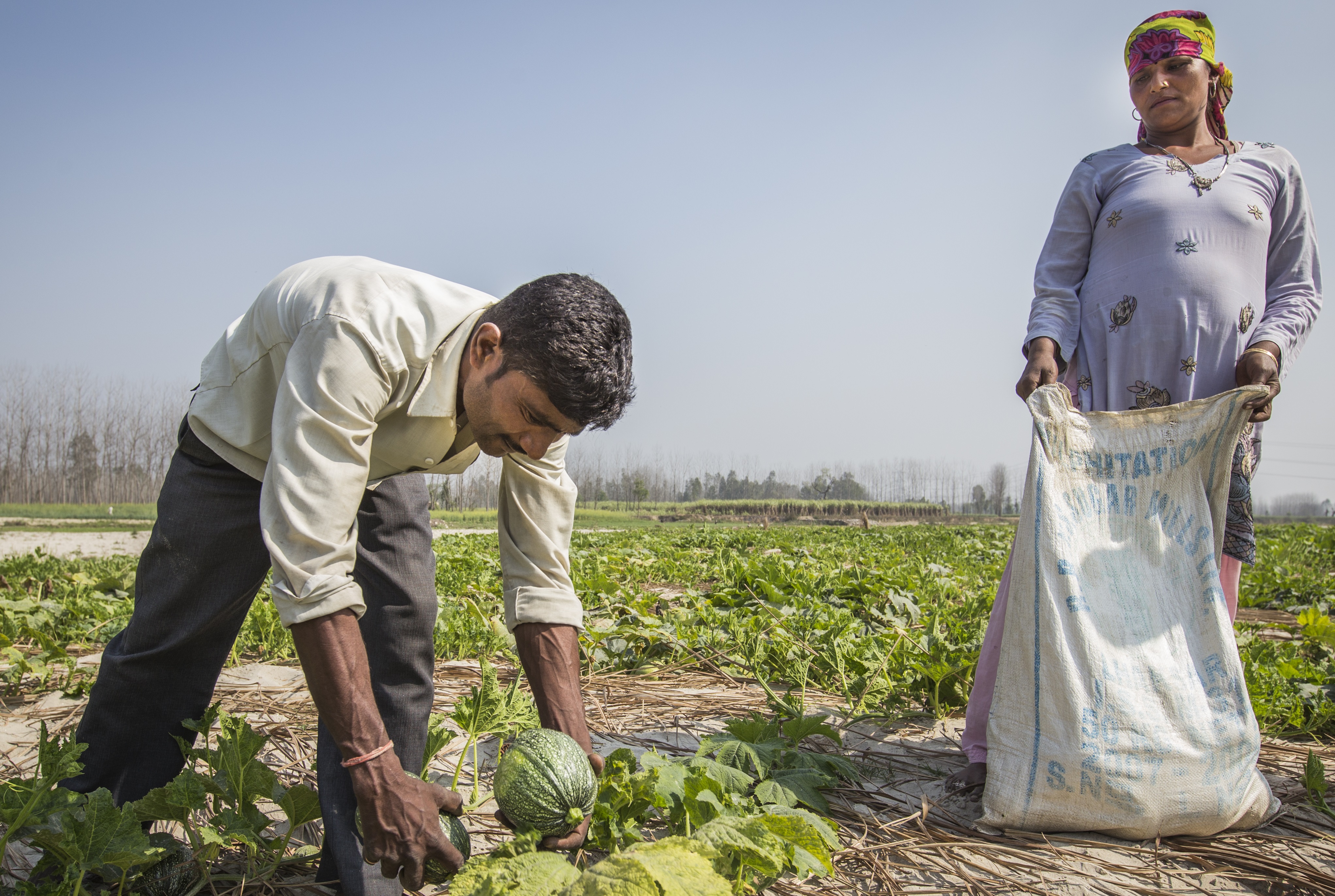
Farmers also influence the timing of crops and tend to grow their crops when weather conditions are more favorable. With these periods shifting due to climate change, sowing calendars are changing over time.

Over thousands of years of domesticating and then breeding crops, humans have also managed to artificially change how crop varieties respond to both temperature and day length, and in turn have been able to expand the area where crop species can be grown. Farmers can now choose varieties that mature at different rates and adapt them to their environment.

Including farmers’ decisions on when to grow crops and which varieties to cultivate are vital ingredients for understanding how climate change is impacting staple crops around the world and how adaptation might offset the negative effects.

In a ground-breaking study, a team of researchers from the Potsdam Institute for Climate Impact Research (PIK), the Technical University of Munich and the International Maize and Wheat Improvement Center (CIMMYT) investigated how farmers’ management decisions affect estimates of future global crop yields under climate change.

“For long time, the parametrization of global crop models regarding crop timing and phenology has been a challenge,” said Sara Minoli, first author of the study. “The publication of global calendars of sowing and harvest have allowed advancements in global-scale crop model and more accurate yield simulations, yet there is a knowledge gap on how crop calendars could evolve under climate change. If we want to study the future of agricultural production, we need models that can simulate not only crop growth, but also farmers’ management decisions.”

Using computer simulations and process-based models, the team projected the sowing and maturity calendars for five staple crops, maize, wheat, rice, sorghum and soybean, adapted to a historical climate period (1986–2005) and two future periods (2060–2079 and 2080–2099). The team then compared the crop growing periods and their corresponding yields under three scenarios: no adaptation, where farmers continue with historical sowing dates and varieties; timely adaptation, where farmers adapt sowing dates and varieties in response to changing climate; and delayed adaptation, where farmers delay changing their sowing dates and varieties by 20 years.

The results of the study, published last year in Nature Communications, revealed that sowing dates driven by temperature will have larger shifts than those driven by precipitation. The researchers found that adaptation could increase crop yields by 12 percent, compared to non-adaptation, with maize and rice showing the highest potential for increased crop yields at 17 percent. This in turn would reduce the negative impacts of climate change and increase the fertilization effect of increased levels of carbon dioxide (CO2) in the atmosphere.

They also found that later-maturing crop varieties will be needed in the future, especially at higher latitudes.

“Our findings indicate that there is space for maintaining and increasing crop productivity, even under the threat of climate change. Unfortunately, shifting sowing dates – a very low-cost measure – is not sufficient, and needs to be complemented by the adaptation of the entire cropping cycle through the use of different cultivars,” said Minoli.

Another important aspect of this study, according to Anton Urfels, CIMMYT systems agronomist and co-author of the study, is that it bridges the GxMxE (Gene-Management-Environment) spectrum by using crop simulations as an interdisciplinary tool to evaluate complex interactions across scientific domains.

“Although the modeled crops do not represent real cultivars, the results provide information for breeders regarding crop growth durations (i.e. the need for longer duration varieties) needed in the future as well as agronomic information regarding planting and harvesting times across key global climatic regimes. More such interdisciplinary studies will be needed to address the complex challenges we face for transitioning our food systems to more sustainable and resilient ones,” said Urfels.

Read the study: Global crop yields can be lifted by timely adaptation of growing periods to climate change

Cover photo: Work underway at the International Maize and Wheat Improvement Center in Zimbabwe (CIMMYT), is seeking to ensure the widespread hunger in the country caused by the 2015/6 drought is not repeated, by breeding a heat and drought tolerant maize variety that can still grow in extreme temperatures. CIMMYT maize breeders used climate models from the CGIAR Research Program on Climate Change, Agriculture and Food Security (CCAFS) to inform breeding decisions. (Photo: L. Sharma/Marchmont Communications)

Managing seeds and agricultural losses in the wake of extreme climate events: Lessons from Nepal

A women farmer picking up lodged paddy field after the untimely flash floods in Nepal (Photo: Sravan Shrestha/ICIMOD)

As climate change-induced disasters surge around the world, it is the people of the least developed countries paying the bulk of the costs.  According to the International Disaster Database, the number of disasters across the globe has risen by 74.5% — comparing data from 1980–1999 with 2000–2019 — and these numbers are expected to increase due to the most recent climate change scenarios. The major climate change impacts identified by the Intergovernmental Panel on Climate Change relevant for Nepal include an increase in economic losses from weather and climate-related events, with a significant contribution related to agricultural losses.

In Nepal, for example, an unexpected and untimely excessive rainfall and flood in October of 2021 caused massive damage to the ready-to-harvest crop across all major rice-producing areas of Nepal – threatening the food security and livelihood of the country’s smallholder rice farmers.

A rice damage assessment was essential to gather insights on the seed production losses and propose anticipatory measures for seed management and distribution to farmers for the next season. Thanks to a collaboration between scientists from the International Maize and Wheat Improvement Center (CIMMYT) and the International Center for Integrated Mountain Development (ICIMOD), a rapid loss assessment through a survey of rice-growing farmers was conducted to quickly assess the damage and recommend critical operational decisions to the Nepali government to mitigate the impact. With the help of an operational mobile app, Geofairy, the USAID-supported Nepal Seed and Fertilizer project (NSAF), implemented by CIMMYT, surveyed 253 farmers in six districts of the mid and far western region with a particular focus on the potential seed production losses for next year’s cultivation.

Unforeseen disaster

The 2021 disaster in Nepal came as a shock to farmers: the 2021 monsoon was proceeding as forecasted in the seasonal outlook, and by the end of the season, farmers were generally expecting bumper rice crops. The withdrawal of southwest monsoon system was declared in early October. However, from 18-20 October 2021, instead of dry spell, the country experienced a three-day excessive rainfall and accompanying flooding that caused massive damage to the ready-to-harvest crop across all major rice-producing areas in the southern lowland Terai region of Nepal.

The partially harvested and standing crop suffered three kinds of damage. First, farmers near the riverbanks lost their ready-to-harvest paddy as it was swept away by flash floods. The second category was in the low-lying southern plains, where rainwater inundated the harvested, but not collected, paddy fields for more than two days, causing seeds or grains on the panicles to sprout. Sprouted seeds on the mother plant have reduced germination capacity and vigor, and cannot be stored for a long period while maintaining the germination capacity. The third damage was stem and root lodging (falling over) due to powerful winds.

Digital technologies for rapid damage assessment

With conventional approaches, on-ground damage assessments after a disaster can take weeks, sometimes months, limiting critical operational decisions in the first few hours and days. However, Nepal’s Ministry of Agriculture and Livestock Development (MoALD) was already prepared: since 2019, the Ministry has been using satellite remote sensing for in-season rice area estimation through the USAID-supported SERVIR HKH program.

Thanks to the platform, experts from ICIMOD were able to share a satellite image-based assessment as early as 22 October 2021: two days after the flood.

This existing digital crop monitoring platform was used to produce a rapid-damage assessment to provide an analytical basis for initial decisions. In the rapid damage assessment, GMP IMERGE satellite data was used to measure the rainfall intensity across Nepal (Figure 1) and Selntinel-1 SAR satellite data was used to map flood water extent in the Terai district of Nepal on 21 October 2022. The assessment also served as a planning tool for in-depth damage evaluation for farmer compensations.

Widespread flooding

Figure 1. Rainfall distribution during 18-20 October 2021 based on the GPM IMERGE satellite precipitation data

Satellite precipitation data showed the occurrence of hefty rainfall in Morang, Sunsari, Saptari, Siraha and Jhapa districts in the Eastern region. In the Western region, Kailali and Kanchanpur experienced intense rainfall, while most of the central districts of the Terai region remained below heavy rain.

Based on satellite images acquired, the flood extent assessment showed major flood spread in the western parts, including Kanchanpur, Kailali, Bardiya and Banke districts (Figure 2). The flood water extent remained lower in the Eastern districts compared to the West. The causes of severe damage were from direct rain pour and winds in the Eastern region, and flood swept from riverbanks in the Western parts.

Figure 2. Flood extent on 21 October 2021 in Kanchanpur district based on the Sentinel-1 satellite data

Assessment results: Reduced seed quality and shortage of rice seed supply for the next planting season

According to a field-based assessment, the two most popular varieties, Radha-4 and Sarju-52, are the most affected by the flood, especially in Banke, Bardiya, Kailali and Kanchanpur districts. Accordingly, 89% of Radha-4 and 42% of Sarju-52 seed production field has faced partial or complete loss in the surveyed districts. As per the district-wise loss assessment, 80% of Sirju-52 grown in Kailali and 61% in Kanchanpur suffered 50-100% damage. Similarly, nearly 60% of Radha-4 grown in Banke and Bardiya districts has suffered a crop loss ranging from 50-100%. This clearly indicates a huge shortage of these varieties for the next rice season which calls for immediate action to mitigate the seed deficit.

The survey found that farmers in Bardiya, Banke and Kailali had severe or complete crop loss, while those in Kanchanpur, Kapilvastu and Rupendehi had partial crop failure (Figure. 3)

Figure 3. Level of rice loss (%) due to flood, based on a rapid crop loss assessment in six districts of Nepal

Losses and the limits of early warning systems

According to the government’s final estimates, about 1,10,000 ha of rice crop area was damaged across the country. Respondents from the western districts reported that 80% of the farmers could only manage 50% or less than the expected harvest. The farmers reported an average input cost of $526 per hectare (NPR 63,162 per ha) and gross expected income of $972 per hectare (NPR 116,674 per ha) – leaving a very narrow margin of profit. To compensate for this economic blow, the government distributed  $43 million (NPR 5.52 billion) among the farmers. However, with a total loss of $0.1 billion (NPR 12 billion), farmers still suffered a great loss.

Figure 4. Percentage of safe harvest in four western districts (Kapilvastu, Rupandehi, Kanchanpur and Bardiya) of Nepal

Although early warning systems were in place in the surveyed districts, some respondents expressed low trust and reliability in the early warnings and only 20% of respondents were aware of the heavy rainfall forecast issued three days before the extreme event. Earlier studies in the Ganges basin have suggested that a 10–20-day lead-time forecast is needed to avoid agriculture losses. However, predicting a high magnitude of low-frequency extreme events with sufficient advance notice is still a significant challenge in climate science.

How to mitigate and weather such challenges?

Nepal’s rice seed replacement rate is around 20%, which means that about 80% of farmers are not accessing good quality seeds every season. The addition of this untimely flash flood and the subsequent seed loss will further worsen seed availability, in turn contributing to food insecurity at the national level. The assessment findings have several implications for actions needed to mitigate future climate shocks.

  • Among other mitigation approaches, stakeholders need to assess in-country level quality rice seed availability and design a plan to mobilize preferred varieties from the surplus districts — less affected by the flood — to those in need.
  • During challenging times, maintaining seed quality standards might be difficult. Hence, stakeholders need to consider adopting a flexible quality standard such as “quality declared seeds” in similar emergency scenarios. The “quality declared seed” standard helps as an important intervention when normal seed production is greatly affected by drought and/or flood. It offers alternative seed quality standards for seed producers to provide seeds and ensure continuity of crop production.
  • Promoting climate-resilient varieties, especially lodging- or submergence-tolerant rice varieties, will better withstand flooding as compared to the susceptible ones.
  • Furthermore, farmers need access to a suitable crop insurance scheme to offset seed losses during extreme weather events. For instance, seed growers can purchase a group insurance scheme where customized premiums could be available to the members.

Some of the above mitigation approaches can be applied when extreme weather events are well forecasted and less severe. However, in the wake of an emerging climate crisis and limited mitigation options, there is a need to balance efforts on all aspects of adaptation, including the adoption of crop management practices including accelerated varietal turnover to modify threats and prevent adverse impacts, strengthen early warning systems with a focus on last-mile connection to minimize damages, and develop innovative mechanisms to address risk transfer and loss and damage compensations for sharing losses.

India’s Groundwater Is In Trouble. And It Could Cause a Food Shortage for Millions By 2025, Study Finds

A recent study of the groundwater in India revealed that, by 2025, large areas of the north-western and southern parts of the country will have “critically low groundwater availability”, leading to a decrease in cropping that will ultimately cause an imbalance in the food security for millions.

Read more: https://www.greenqueen.com.hk/indias-groundwater-is-in-trouble-and-it-could-cause-a-food-shortage-for-millions-by-2025-study-finds/

Groundwater depletion in India could reduce winter cropped acreage significantly in years ahead

Water pumped from a deep irrigation well, called a tube well, at a wheat farm in west India's Gujarat state. (Photo: Meha Jain)
Water pumped from a deep irrigation well, called a tube well, at a wheat farm in west India’s Gujarat state. (Photo: Meha Jain)

India is the world’s second-largest producer of wheat and rice and is home to more than 600 million farmers. The country has achieved impressive food-production gains since the 1960s, due in part to an increased reliance on irrigation wells, which allowed Indian farmers to expand production into the mostly dry winter and summer seasons.

But those gains have come at a cost: The country that produces 10% of the world’s crops is now the world’s largest consumer of groundwater, and aquifers are rapidly becoming depleted across much of India. Indian government officials have suggested that switching from groundwater-depleting wells to irrigation canals, which divert surface water from lakes and rivers, is one way to overcome projected shortfalls.

In a study published in the journal Science Advances, scientists conclude that a switch to canal irrigation will not fully compensate for the expected loss of groundwater in Indian agriculture.

The authors estimate that if Indian farmers lose all access to groundwater in overexploited regions, and if that irrigation water is not replaced with water from other sources, then winter cropped acreage could be reduced by up to 20% nationwide. However, that scenario seems highly unlikely and was included in the study only as an upper-bound estimate.

It seems more likely that any future groundwater shortfalls would be at least partially offset by increases in canal irrigation. But even if all Indian regions currently using depleted groundwater switch to canal irrigation, winter cropped acreage could still decline by 7% nationwide and by 24% in the most severely affected locations, according to the researchers.

Water alternatives needed

“Our results highlight the critical importance of groundwater for Indian agriculture and rural livelihoods, and we were able to show that simply providing canal irrigation as a substitute irrigation source will likely not be enough to maintain current production levels in the face of groundwater depletion,” said study lead author Meha Jain, an assistant professor at the University of Michigan’s School for Environment and Sustainability.

“We need coordinated efforts to solve this water availability and food security issue, which should be supported by science-led policy decisions on what strategies and technology solutions to scale out to improve irrigation efficiency,” said co-author Balwinder Singh, a Cropping Systems Simulation Modeler at the International Maize and Wheat Improvement Center (CIMMYT).

The study analyzed high-resolution satellite imagery and village-level census data and focused on winter cropped acreage. While nearly all Indian farmers plant crops during the monsoon to take advantage of seasonal rains, winter agriculture is mainly reliant on groundwater irrigation and now accounts for 44% of the country’s annual cropped acreage for food grains.

“These findings suggest that other adaptation strategies, in addition to canal expansion, are needed to cope with ongoing groundwater losses,” Jain said.

The possibilities include switching from winter rice to less water-intensive cereals, increased adoption of sprinklers and drip irrigation to conserve water in the fields, and policies to increase the efficiency of irrigation canals.

While groundwater depletion is becoming a global threat to food security, and the extent of current and projected groundwater depletion are well documented, the potential impacts on food production remain poorly quantified. The study is the first to use high-resolution empirical data, including census data about the irrigation methods used in more than 500,000 Indian villages, to estimate the crop production losses that may occur when overexploited groundwater is lost.

“Understanding the complex relationship between food security and water availability is crucial as we prepare for future rainfall variability due to global climate change,” said co-author Gillian Galford of the University of Vermont.

The proliferation of deep (>30 meters) irrigation wells called tube wells since the 1960s has enabled Indian farmers to increase the number of seasons when crops are planted in a given year. This increase in “cropping intensity” is credited for much of the country’s food-production gains.

Maps showing state-by-state Indian winter cropped area loss estimates due to groundwater depletion in coming decades, with and without replacement by canals. Darker shades of pink and red indicate greater projected losses. The map on the left (A) shows projected winter cropped acreage losses if all critically depleted groundwater is lost, with no replacement. The map on the right (B) shows projected winter cropped acreage losses if groundwater irrigation is replaced with canals, using national-level regression coefficients. (Graph: Jain et al. in Science Advances 2021)

Big data for food security

The researchers used satellite data to measure Indian winter cropped area, a key determinant of cropping intensity. They then linked the satellite data to census information about the three main types of irrigation infrastructure in India: shallow “dug wells,” deeper tube wells and canals that divert surface water.

Linking the two datasets allowed them to determine the relative efficacy of each irrigation method. That, in turn, enabled them to estimate potential future acreage losses and the ability of canal expansion to fill the gap.

The study’s worst-case scenario found that winter cropped area could decrease by up to 20% nationwide and by 68% in the most severely affected regions, if farmers lose all access to groundwater and if that irrigation water is not replaced from another source. The expected losses would largely occur in northwest and central India, according to the study.

The researchers also found that increased distance from existing irrigation canals is strongly associated with decreased acreage planted with winter crops. In the future, a greater reliance on canals could increase inequities related to irrigation access, according to the authors.

“This suggests that while canals may be a viable form of irrigation for those who live near canals, they may lead to more unequal access to irrigation across villages compared to wells, with negative impacts for those who live farther from canals,” the authors wrote.

In addition, the lakes and rivers that feed irrigation canals rise and fall in response to rainfall variability, unlike deep groundwater wells. So, a greater reliance on canal irrigation in the future would result in increased sensitivity to year-to-year precipitation fluctuations, as well as any long-term trends due to human-caused climate change.

The authors of the Science Advances study, in addition to Jain and Galford, are Ram Fishman of Tel Aviv University; Pinki Mondal of the University of Delaware; Nishan Bhattarai of the U-M School for Environment and Sustainability; Shahid Naeem, Upmanu Lall and Ruth DeFries of Columbia University; and Balwinder Singh of the International Maize and Wheat Improvement Center (CIMMYT).

The work was funded by a NASA New Investigator Award to Jain and two NASA Land Cover and Land Use Change grants, one awarded to R.S. DeFries and one to Jain.

——

RELATED RESEARCH PUBLICATIONS:

Groundwater depletion will reduce cropping intensity in India

INTERVIEW OPPORTUNITIES:

Balwinder Singh – Cropping Systems Simulation Modeler, CIMMYT

Meha Jain – Assistant Professor, University of Michigan

FOR MORE INFORMATION, OR TO ARRANGE INTERVIEWS, CONTACT THE MEDIA TEAM:

Rodrigo Ordóñez – Communications Manager, CIMMYT. r.ordonez@cgiar.org

Jim Erickson – Lead Public Relations Representative, University of Michigan. ericksn@umich.edu

Scientists propose a low-cost, reliable system to measure soil organic carbon

A multi-crop, multi-use zero-tillage seeder at work on a conservation agriculture trial plot, left, at CIMMYT's headquarters in Texcoco, Mexico. The residues retained on the soil surface and the permanent raised beds are in clear contrast with the conventional plot on the right. (Photo: CIMMYT)
A multi-crop, multi-use zero-tillage seeder at work on a conservation agriculture trial plot, left, at CIMMYT’s headquarters in Texcoco, Mexico. The residues retained on the soil surface and the permanent raised beds are in clear contrast with the conventional plot on the right. (Photo: CIMMYT)

New research by an international team of scientists, including International Maize and Wheat Improvement Center (CIMMYT) Director for the Integrated Development Program, Bram Govaerts, outlines a proposed accounting system for organic carbon in soils that could encourage farmers to adopt better land management practices and increase levels of organic carbon in their soil.

Reported this month in the journal Carbon Management, the study highlights how increasing soil organic carbon (SOC) would build agricultural resilience and fertility and reduce greenhouse gas emissions — but we need to be able to measure it.

Soil is a huge carbon reservoir — in fact, soils contain one of the largest organic carbon stocks on the planet. With proper land management, soils have the potential to store even more. Improved SOC levels have also been connected with improved soil quality, reduced susceptibility to erosion and greater agricultural yields and yield stability, particularly under drought. This makes them a crucial player in climate change mitigation and agricultural resilience.

Policy makers and environmental groups are becoming increasingly interested in soil health and its effect on climate change. The 4 per 1000 initiative, launched at the COP 21 climate talks in Paris in 2015, argues that an annual growth rate of 0.4% in soil carbon stocks would significantly reduce human activity-related CO2 concentrations in the atmosphere. The most recent Intergovernmental Panel on Climate Change (IPCC) assessment highlights carbon sequestration as one of the options, alongside massive fossil fuel reduction, to keep warming below 2 degrees Celsius, in accordance with the Paris Climate Agreement.

Increasing organic carbon content in soils also has another very important function: crop nutrition. Last year, researchers from CIMMYT and the Nature Conservancy found that wheat grown on soils rich in organic matter had more essential nutrients like zinc and protein.

However, increasing levels of organic carbon in the soil can be costly in the short term, so farmers need to see improvements in the performance of their soils as a result of their efforts.

Quantifying soil carbon

That’s where a global soil information system comes in. By integrating empirical models, expanded measurement and monitoring networks, remote sensing and crowdsourced management data, SOC stocks can be assessed efficiently and reliably. Farmers and policy makers would get a clear picture of how much soil organic carbon is increasing and at what rate.

The global soil information system would work by pulling different sources of existing information together to provide a comprehensive account of soil organic carbon stocks worldwide.

As SOC content can vary over time, an important component of the system would involve using monitoring networks at precise locations which can then be resampled regularly. Alongside this information, empirical models would be used to predict SOC changes based on already observed results from lab- and field-based experiments, and to predict the impacts of different soil and climate conditions. Remote sensing data can provide information on land cover, crop species and land management practices at a very low cost, to supplement and verify management activity data reported by land users.

The international team of scientists pointed out that greater coordination and transparency among scientists, remote sensing specialists and land managers is crucial to the success of a global soil information system.

Incentivizing carbon sequestration among land managers is no mean task. The authors argue that existing approaches like direct compensation to farmers for CO2 removal and storage, government subsidies such as the European Union’s Common Agricultural Policy (CAP) and the option of earning a premium price for producing sustainable agricultural products, need a reliable carbon accounting system to ensure their success. A global soil information system might just hold the key.

Read the full article:
“Quantifying carbon for agricultural soil management: from the current status toward a global soil information system” in Carbon Management, DOI: 10.1080/17583004.2019.1633231

This study was made possible through the support provided by the TomKat Foundation. Additional support was provided by the NASA Harvest Consortium (www.nasaharvest.org), a multi-disciplinary program that empowers informed agricultural decisions through the use of Earth observations.

New drought monitoring system will reduce climate risks for South Asian farmers

Farmers harvest squash in Uttarakhand, India. (Photo: Jitendra Raj Bajracharya/ICIMOD)

To mitigate the food security and economic risks of South Asia’s frequent and intense droughts, scientists and policymakers from the South Asian Association for Regional Cooperation (SAARC), the International Centre for Integrated Mountain Development (ICIMOD) and the International Maize and Wheat Improvement Center (CIMMYT) recently joined forces to launch an innovative decision support and agricultural planning system that combines remote sensing and  climate data analysis for drought monitoring and early warning.

The Regional Drought Monitoring and Outlook System application was unveiled during a workshop to train experts and policymakers in its use at relevant regional and national institutes in Islamabad, Pakistan, from July 29 to August 1, 2019. The Regional Drought Monitoring and Outlook System is the product of an ICIMOD-CIMMYT partnership through the United States Agency for International Development (USAID) and the National Aeronautics and Space Administration (NASA) supported SERVIR Hindu Kush Himalaya (HKH) programme, in collaboration with Climate Service for Resilient Development (CSRD), led by ICIMOD and CIMMYT, respectively.

“Commonly associated with epic flooding, particularly in the enormous breadbasket region known as the Indo-Gangetic Plains that extends across Pakistan, India, southern Nepal, and Bangladesh, the region also faces droughts driven by rising temperatures and erratic rainfall and which threaten crops, food security, and livelihoods,” said Faisal Mueen Qamer, Remote Sensing Specialist of ICIMOD, which helped develop the system and organize the workshop.

“We expect the system to foster resilience in South Asian agriculture, while supporting future institutional frameworks and policies for farm compensation and adaptation, through decision makers’ access to timely and action-oriented information,” Qamar explained.

With a growing population of 1.6 billion people, South Asia hosts 40% of the world’s poor and malnourished on just 2.4% of its land. A 2010 study found a linear drop of 7.5% in rainfall in South Asia from 1900 to 2005.

“Shrinking glaciers, water scarcity, rising sea levels, shifting monsoon patterns, and heat waves place considerable stress on South Asian countries, whose primary employment sector remains agriculture,” said Mohammad Faisal, Director General for South Asia at Pakistan’s Ministry of Foreign Affairs, during the workshop opening.

Media reports in early 2019 documented displacement and hunger from Pakistan’s worst drought in years.

Participants at the regional workshop on earth observation and climate data analysis for agriculture drought monitoring in South Asia. (Photo: ICIMOD)

Raising awareness about drought and its mitigation

Twenty-three participants from six South Asia countries plus five expert instructors attended the workshop, which offered presentations and hands-on training on a suite of applications and associated data analysis tools, including the South Asian Land Data Assimilation System (SALDAS), the Regional Drought Explorer, and the National Drought Early Warning System.

Muhammad Azeem Khan, Member of the Food Security & Climate Change at the Planning Commission of Pakistan, said the scale of present and future climate challenges is clearly evident.

“In Pakistan, we regularly see parts of the country in the grip of severe drought, while others have flash floods,” Khan commented during the workshop closing, while commending its organizers. “Frequent drought diminishes agricultural production and food security, especially for people in rural areas. Effectively managing the impacts of climate change requires a response that builds and sustains South Asia’s social, economic, and environmental resilience, as well as our emergency response capacity.”

Through CSRD, a global partnership that connects climate and environmental science with data streams to generate decision support tools and training for decision-makers in developing countries, CIMMYT helped extend the Regional Drought Monitoring and Outlook System to Bangladesh, from its original coverage of Afghanistan, Nepal, and Pakistan.

“Translating complex climate information into easy-to-understand and actionable formats is core to CSRD’s mission and helps spread awareness about climate challenges,” said Tim Krupnik, CIMMYT cropping systems agronomist based in Bangladesh. “This consortium provides strength and technical expertise to develop relevant climate products, including decision-support information for farmers and other stakeholders, thus fostering resilience to climate-related risks.”