funder_partner: Columbia University

Gridded crop modeling to simulate impacts of climate change and adaptation benefits in ACASA

Global temperatures are projected to warm between 1.5-2 degrees Celsius by the year 2050, and 2-4 degrees Celsius by 2100. This is likely to change precipitation patterns, which will impact crop yields, water availability, food security, and agricultural resilience.

To prepare for these challenges, Atlas of Climate Adaptation in South Asian Agriculture (ACASA) uses process-based simulation models that can predict crop growth, development, and yield in order to understand the response of crops to climate change. Models such as Decision Support System for Agrotechnology Transfer (DSSAT), InfoCrop, and Agricultural Production Systems Simulator (APSIM) facilitate the field scale study of the biophysical and biochemical processes of crops under various environmental conditions, revealing how they are affected by changing weather patterns.

The ACASA team, along with experts from Columbia University and the University of Florida, met for a three-day workshop in January 2024 to boost the work on spatial crop modeling. The aim was to design a modeling protocol through a hands-on demonstration on high-performance computers. When scientifically executed, gridded spatial crop modeling–even though complex and data-intensive–can be a great way to frame adaptation and mitigation strategies for improving food security, which is one of ACASA’s goals.
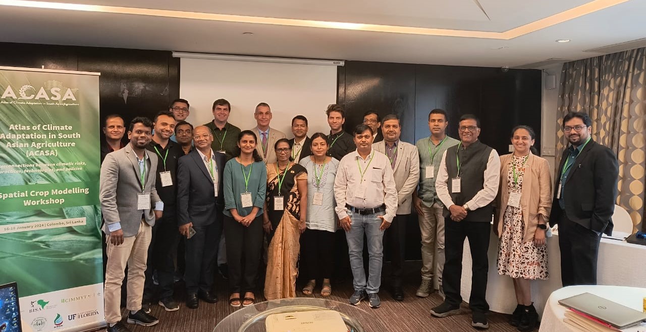
ACASA’s Spatial Crop Modelling Group meets in Colombo, Sri Lanka, January 2024. (Photo: CIMMYT)

Decisions on data

The group decided to use DSSAT, APSIM, and InfoCrop for simulating the impact of climatic risks on crops such as rice, wheat, maize, sorghum, millet, pigeon pea, chickpea, groundnut, soybean, mustard, potato, cotton, and more. They chose harmonized protocols across all three models with standard inputs, such as conducting simulations at 0.05 degrees. The model input data about weather, soil, crop varietal coefficients, and crop management are being collected and processed for model input formats at 5 kilometer (km) spatial resolution.

A Python version called DSSAT-Pythia is now available to accelerate spatial and gridded applications. The programming for implementing InfoCrop on the Pythia platform is in progress. InfoCrop has been proven in India for past yield estimations, climate change spatial impact, and adaptation assessments for 12 crops.

For other crucial modeling components, a work plan was created including developing regional crop masks, crop zones based on mega-commodity environments as defined by CGIAR, production systems, crop calendars, and irrigated areas by crop. Genetic coefficients will then be calculated from measured past values and recent benchmark data of varietal units.

With this information, several adaptation options will be simulated, including changes in planting dates, stress-tolerant varieties, irrigation, and nitrogen fertilizer (quantity, methods, and technology), residue/mulching, and conservation tillage. The team will evaluate impact and adaptation benefits on yields, water, and nitrogen-use efficiency based on the reported percentage change from the baseline data.

As the project progresses, this work will make strides towards realizing food security for the planet and increasing the resilience of smallholder farming practices.

Blog written by Anooja Thomas, University of Florida; Apurbo K Chaki, BARI, Bangladesh; Gerrit Hoogenboom, University of Florida; S Naresh Kumar, ICAR-IARI, India
How a policy to address a groundwater shortage inadvertently increased air pollution in northern India

A recent study by Harvard University, the Jet Propulsion Laboratory, Environmental Defense Fund (EDF), the University of Michigan, the Public Health Foundation of India, the International Maize and Wheat Improvement Center (CIMMYT), Columbia University, and the University of California, Los Angeles, has determined the environmental impact of a government policy of delayed rice planting in northwest India.

As explained in an article for the Tech and Science Post, farmers had to push back rice sowing to take advantage of monsoon rains and decrease reliance on groundwater-fed irrigation systems. However, this led to farmers relying on fire to quickly clear fields ready for the next planting season, thereby exacerbating air pollution in the region.

“We have shown that the groundwater and air quality crises are major regional issues and are interconnected,” said co-author Balwinder-Singh, former Cropping System Scientist at the International Maize and Wheat Improvement Center (CIMMYT) in New Delhi. “But there is still a path to clearer skies and safer water practices. Local solutions include planting rice varieties that either grow more quickly or need less water. Promoting less water-demanding crops like maize would be helpful in zones with severe groundwater depletion.”

Read the original article: How a policy to address a groundwater shortage inadvertently increased air pollution in northern India

Launching digital agro-climate advisory platform in Ethiopia

In this era of climate emergency, what is left when traditional knowledge is no longer enough?

In the midst of Ethiopia’s exponential population climb and the strikes of the climate emergency with erratic rains, dry spells, sharp floods and failed crops, the country launched a digital agro-climate advisory platform, called EDACaP, to put resilience at the center of agricultural livelihoods.

A team effort led by the Ethiopian Institute of Agricultural Research (EIAR) in partnership with the Ministry of Agriculture (MoA) and the National Meteorological Agency (NMA), alongside numerous research centers and programs: the International Center for Tropical Agriculture (CIAT), the International Maize and Wheat Improvement Center (CIMMYT), the CGIAR Research Program on Climate Change, Agriculture and Food Security (CCAFS) and the International Research Institute for Climate and Society (IRI), with support from the Agricultural Growth Program (AGP), the EDACaP has come to life.

Read more here: https://www.thereporterethiopia.com/article/launching-digital-agro-climate-advisory-platform-ethiopia

Climate Services for Resilient Development in South Asia (CSRD)

Climate Services for Resilient Development (CSRD) is a global partnership that connects climate and environmental science with data streams to generate decision support tools and training for decision-makers in developing countries. Translating complex climate information into easy to understand actionable formats to spread awareness in the form of climate services is core to CSRD’s mission. CSRD works across South Asia (with emphasis on Bangladesh), the Horn of Africa (Ethiopia), and in South America (Colombia) to generate and provide timely and useful climate information, decision tools and services. In South Asia, CSRD focusses the development, supply and adaptation of agricultural climate services to reduce vulnerability by increasing resiliency in smallholder farming systems. These goals are strategically aligned with the Global Framework for Climate Services.

Project description

CSRD in South Asia aims to have the impact by increasing climate resilient farm management, indicated by increased use of climate services and climate information to inform farmers on how to better manage their production systems.  CSRD also aims to develop and validate models for agricultural climate services that can be replicated in other regions with similar farming systems and climate risks, while also fine-tuning weather and climate advisories to be most useful to farmers’ decision-making. A series of sustained contributions to CSRD’s Action and Learning Framework Pillars 1-4, detailed below, are envisioned as major project outcomes:

  • Pillar 1: Create the solution space:
    CSRD works to establish a problem-focus, to engage key stakeholders, to create a platform for sustained communication and collaboration, and to build synergies among relevant programs.
  • Pillar 2: Utilize quality data, products, and tools
    CSRD provides access to useful and available information and technology, and to develop tailored products and services responsive to problem-specific needs.
  • Pillar 3: Build capacities and platforms
    CSRD supports the use of targeted products and services, and to promote sustainability, scalability, and replicability.
  • Pillar 4: Build knowledge
    A key goal of CSRD’s work is to identify and promote good practices among the global climate services community and to support research efforts and innovation that increase the effectiveness of climate services.

Outputs

CSRD in South Asia will ultimately generate the following broad outputs and services:

Download the report summarizing CSRD activities, achievements, and challenges during the first year (from November 2016 through December 2017).

The CSRD consortium in South Asia is led by the International Maize and Wheat Improvement Center (CIMMYT) in partnership with the Bangladesh Meteorological Department (BMD), Bangladesh Department of Agricultural Extension (DAE), Bangladesh Agricultural Research Council (BARC), Bangladesh Agricultural Research Institute (BARI), International Center for Integrated Mountain Development (ICIMOD), International Institute for Climate and Society (IRI), University de Passo Fundo (UPF), and the University of Rhode Island (URI). This consortium provides strength and technical expertise to develop relevant climate products that can assist farmers and other stakeholders with relevant information to improve decision making, with the ultimate goal of increasing resilience to climate-related risks. The CSRD consortium also works to assure that climate information can be conveyed in ways that are decision-relevant to farmers and other agricultural stakeholders.

As a public-private partnership, CSRD is supported by the United States Agency for International Development (USAID), UK AID, the UK Met Office, the Asian Development Bank (ADB), the Inter-American Development Bank (IDB), ESRI, Google, the American Red Cross, and the Skoll Global Threats Fund.

Climate insurance for farmers: a shield that boosts innovation

Index insurance is one of the top 10 innovations for climate-proof farming. Photo: P. Lowe/ CIMMYT

What stands between a smallholder farmer and a bag of climate-adapted seeds? In many cases, it’s the hesitation to take a risk. Farmers may want to use improved varieties, invest in new tools, or diversify what they grow, but they need reassurance that their investments and hard work will not be squandered.

Climate change already threatens crops and livestock; one unfortunately-timed dry spell or flash flood can mean losing everything. Today, innovative insurance products are tipping the balance in farmers’ favor. That’s why insurance is featured as one of 10 innovations for climate action in agriculture, in a new report released ahead of next week’s UN Climate Talks. These innovations are drawn from decades of agricultural research for development by CGIAR and its partners and showcase an array of integrated solutions that can transform the food system.

Index insurance is making a difference to farmers at the frontlines of climate change. It is an essential building block for adapting our global food system and helping farmers thrive in a changing climate. Taken together with other innovations like stress-tolerant crop varieties, climate-informed advisories for farmers, and creative business and financial models, index insurance shows tremendous promise.

The concept is simple. To start with, farmers who are covered can recoup their losses if (for example) rainfall or average yield falls above or below a pre-specified threshold or ‘index’. This is a leap forward compared to the costly and slow process of manually verifying the damage and loss in each farmer’s field. In India, scientists from the International Water Management Institute (IWMI) and the Indian Council of Agricultural Research (ICAR), have worked out the water level thresholds that could spell disaster for rice farmers if exceeded. Combining 35 years of observed rainfall and other data, with high-resolution satellite images of actual flooding, scientists and insurers can accurately gauge the extent of flooding and crop loss to quickly determine who gets payouts.

The core feature of index insurance is to offer a lifeline to farmers, so they can shield themselves from the very worst effects of climate change. But that’s not all. Together with my team, we’re investigating how insurance can help farmers adopt new and improved varieties. Scientists are very good at developing technologies but farmers are not always willing to make the leap. This is one of the most important challenges that we grapple with. What we’ve found has amazed us: buying insurance can help farmers overcome uncertainty and give them the confidence to invest in new innovations and approaches. This is critical for climate change adaptation. We’re also finding that creditors are more willing to lend to insured farmers and that insurance can stimulate entrepreneurship and innovation. Ultimately, insurance can help break poverty traps, by encouraging a transformation in farming.

Insurers at the cutting edge are making it easy for farmers to get coverage. In Kenya, insurance is being bundled into bags of maize seeds, in a scheme led by ACRE Africa. Farmers pay a small premium when buying the seeds and each bag contains a scratch card with a code, which farmers text to ACRE at the time of planting. This initiates coverage against drought for the next 21 days; participating farms are monitored using satellite imagery. If there are enough days without rain, a farmer gets paid instantly via their mobile phone.

ACRE makes it easy for Kenyan farmers to get insurance. Source

Farmers everywhere are businesspeople who seek to increase yields and profits while minimizing risk and losses. As such, insurance has widespread appeal. We’ve seen successful initiatives grow rapidly in India, China, Zambia, Kenya and Mexico, which points to significant potential in other countries and contexts. The farmers most likely to benefit from index insurance are emergent and commercial farmers, as they are more likely than subsistence smallholder farmers to purchase insurance on a continual basis.

It’s time for more investment in index insurance and other innovations that can help farmers adapt to climate change. Countries have overwhelmingly prioritized climate actions in the agriculture sector, and sustained support is now needed to help them meet the goals set out in the Paris Climate Agreement.

Jon Hellin leads the project on weather index-based agricultural insurance as part of the CGIAR Research Program on Climate Change, Agriculture and Food Security (CCAFS). This work is done in collaboration with the International Research Institute for Climate and Society (IRI) at Columbia University, and the CGIAR Research Programs on MAIZE and WHEAT.

Find out more 

Report: 10 innovations for climate action in agriculture

Video: Jon Hellin on crop-index insurance for smallholder farmers

Info note: Prospects for scaling up the contribution of index insurance to smallholder adaptation to climate risk

Report: Scaling up index insurance for smallholder farmers: Recent evidence and insights.

Website: Weather-related agricultural insurance products and programs – CGIAR Research Program on Climate Change, Agriculture and Food Security (CCAFS)